
North Carolina officials called for a state of emergency on Sunday night. Several counties have been under this State of emergency as hazardous conditions arose. Governor Josh Stein directed local authorities to respond to these escalations as crisis response teams were dispatched, showcasing a real risk becoming apparent in the State.
Residents in affected counties were urged to limit travel and prepare for emergency instructions. All of these measures were in the interest of public and property safety.
Affected Counties
Four counties have received the State of emergency, which are Alamance, Person, Moore, and Orange counties. As conditions surrounding flooding escalated, officials coordinated with state agencies to mitigate serious injury and inform residents.
Other measures were taken, including opening emergency shelters and putting out evacuation advisories for neighborhoods most vulnerable to the water level.
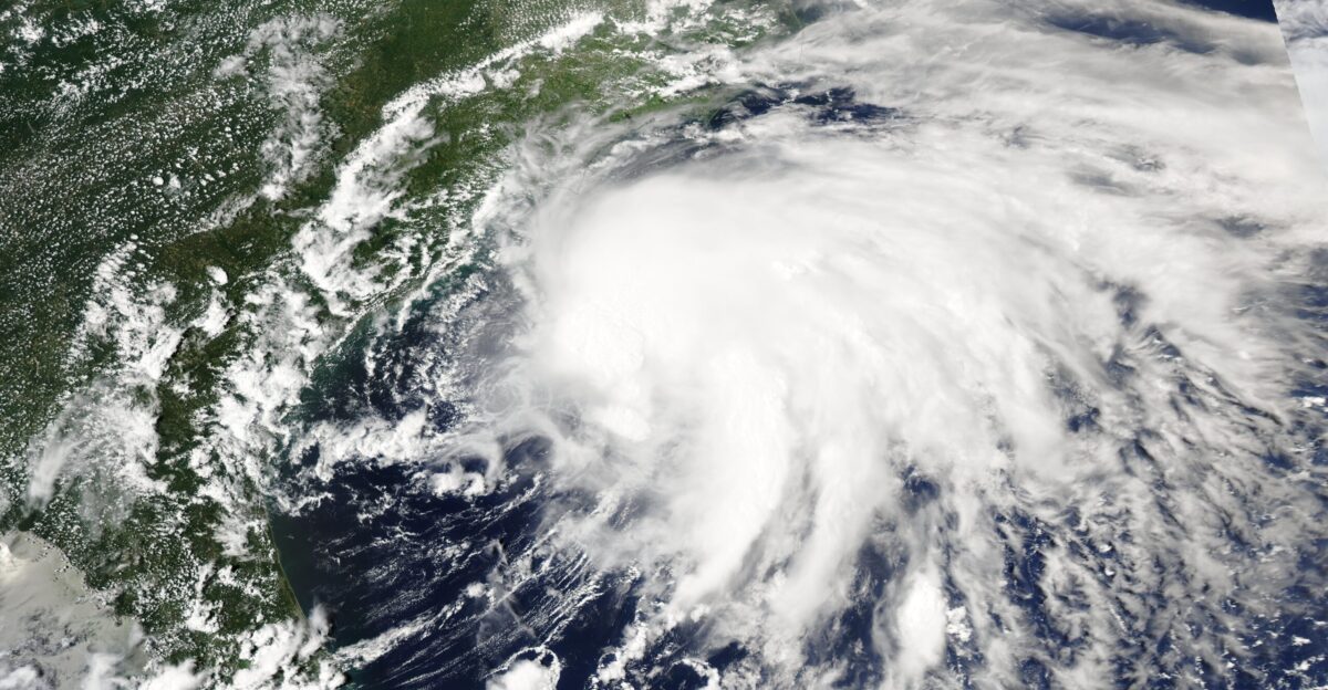
Tropical Depression Chantal

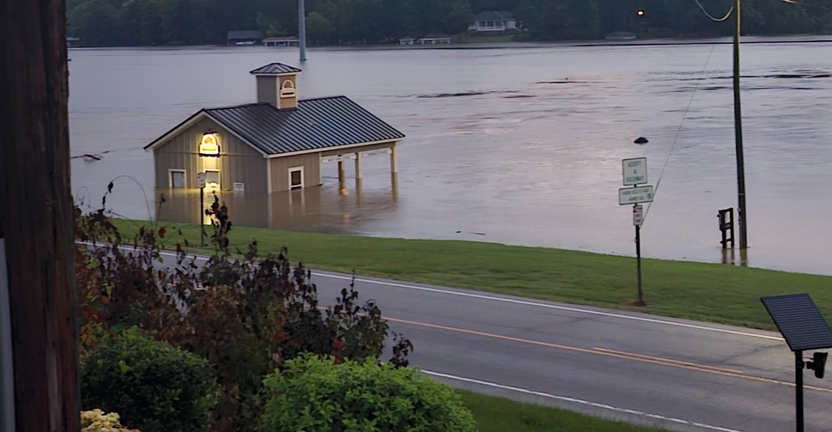
Overnight, many residents didn’t know the true cause and State of the hazardous conditions, but by Monday morning, it was apparent that Tropical Depression Chantal caused the flooding. Staggering rainfall overwhelmed rivers and creeks, causing them to overflow and putting many communities in jeopardy, with numerous roads completely underwater.
The National Weather Service has said that rainfall was at record levels in several areas, as some were faced with 11 inches in mere hours. When the sun came up, the damage was clear to see.
The Aftermath
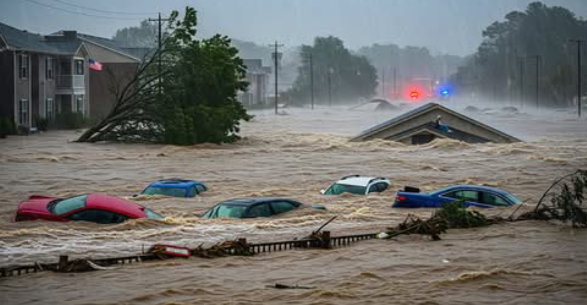
Crisis teams worked tirelessly through the night as emergency calls came in. Towns like Chapel Hill were hit especially hard, and over the course of the night, over 100 water rescues had to be conducted. Many homes were completely flooded, and emergency teams put their lives at risk evacuating those in imminent danger.
Shelters quickly filled up as people in Orange County became displaced by the flooding, and conditions quickly worsened. If not for the efforts of crisis response teams, the tragedy would have been even greater.
Infrastructure Damage
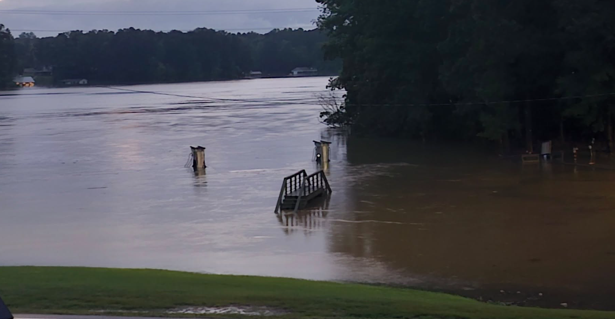
Not only were the lives of many residents put in jeopardy, but infrastructure damages were reported around the State. More than 100 roads had to be closed as floodwater rose to dangerous levels, including high-traffic routes such as interstates.
The flooding affected power, as nearly 20,000 residents reported being in the dark. Many routes for rescuers were inaccessible, making rescue efforts even more complex. Public health concerns rose as water treatment plants were affected by power outages. According to the North Carolina Emergency Management Agency, all of the disruptions that the flooding had on services could take days to restore.
Impact On People

The flood has had an unprecedented impact on people in severe regions. There have already been deaths attributed to the flooding, including an elderly woman who was carried away in her car by the flood. Even more people remained missing as of Monday afternoon.
The toll on families is devastating, but could have been far worse without rescue efforts. Governor Stain stated, “I am grateful to the first responders who are keeping people safe and for the proactive work of emergency management professionals and the North Carolina Department of Transportation.”
Agricultural And Economic Impact

The flooding’s effects spilled into North Carolina’s agricultural sector, as there are reports of both crops and livestock being lost. Person County has seen it at its worst, with nearly half of the tobacco, soybean, and corn crops destroyed. Many fields were kept underwater and couldn’t be harvested.
Fortunately, livestock losses in Alamance County weren’t as high as they could have been, with efforts to evacuate animals to higher ground before the worst of the flooding occurred. Other farms aren’t as fortunate and have reported losses of chickens.
Impact On Wildlife

Wildlife wasn’t spared the wrath of the flood, as many animals that live underground in dens and birds’ nests were displaced. Even aquatic animals were disrupted as their habitats changed rapidly with the flood waters.
The flood has impacted the lives of everybody living in the most severe regions, highlighting the devastation that Mother Nature can inflict in the blink of an eye.
Ongoing Warnings
Even once the unforgiving rain stopped, flooding persisted in many areas as rivers overflowed and flash flooding became a possibility downstream.
The National Weather Service continues to monitor the situation, and residents are urged to stay informed through alerts. DriveNC.gov provides information regarding road closures and travel safety.
The Road Ahead

The flooding in many North Carolina counties has showcased how quickly dangerous conditions can become and possible vulnerabilities in the State’s preparedness.
However, the rapid response of crisis teams shouldn’t be downplayed either, and many people were rescued and informed of the situation. The road ahead will be one of recovery and awareness, as natural disasters can strike anytime.


